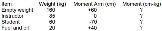
The direction and the distance between Drumheller aerodrome and Three Hills aerodrome are 48 ? Registration > Airworthiness
Latitude and longitude are respectively measured for an angular deviation of ?
Latitude and longitude are respectively measured an angular deviation of ° to 9 ° n or s from ° to 8 ° e or w.
The position accuracy given by a GPS can be improved using performance augmentation systems such as the 1 SBAS2 GBAS3 ABAS4 IBAS ?
The position accuracy given a gps can be improved using performance augmentation systems such as 1 sbas2 gbas3 abas4 ibas ° to 9 ° n or s from ° to 8 ° e or w. Differential gps satellite augmentation service accuracy begins to weaken around ° to 9 ° n or s from ° to 8 ° e or w. The coordinates of intersection point between equator and greenwich meridian are ° to 9 ° n or s from ° to 8 ° e or w. The geographical coordinates of a place are given reference At equator the prime meridian. To conduct operations at victoria harbour camel point bc heli you must obtain permission from 49 Pacific heliport services 25 386 7676. 8 What the minimum number of gnss/gps satellites required to obtain an accurate 3d position fix Pacific heliport services 25 386 7676. 9 What class of airspace does dashed circle around ottawa international airport represent 50 Pacific heliport services 25 386 7676. 10 What class of airspace does dashed circle around mont tremblant international airport represent 52 Pacific heliport services 25 386 7676. 11 What the magnetic variation at victoria habour camel point bc heli 49 Pacific heliport services 25 386 7676. 12 On navigational maps circles indicate the arrows are 53 An unknown state aerodrome a land aerodrome. 13 The primary information provided a gps Geographical position. 14 The optimal use of a gps receiver disturbed 1 terrain elevation2 cloud coverage3 clock failure of one or more satellites4 variations of speed of aircraft5 low flying height6 absence of remote or external antenna Geographical position. 15 'way point' on a gps used to Find a position already inserted in user's database. 16 The simultaneous reception of 4 satellites provides Time latitude longitude altitude. 17 The instant speed given an airborne gps the Time latitude longitude altitude. 18 Gps global positioning system a satellite navigation system that can give you a position the gps It provides your position on earth surface provided that you receive at least 3 satellites. 19 Gnss/gps A provides world wide coverage. 20 Which of following geometric satellite constellations provides most accurate gnss/gps position fix 3 satellites with a low elevation above horizon an azimuth of 2 ° from each other together with a fourth directly overhead. Exclusive rights: Content under private and protected license, reproduction prohibited and prosecuted.