Given Chart scale is 1 500 000 The chart distance between two points is 4 centimetres Earth distance is approximately ? Quiz > helipad
4 cm x 500 000 cm = 2 000 000 cm = 20 km.
Given Chart scale is 1 500 000 The chart distance between two points is 27 centimetres Earth distance is approximately ?
Given chart scale 1 500 000 the chart distance between two points 27 centimetres earth distance approximately 1 cm on chart 500 000 cm soit 5000 m or 5 km
27 x 5 = 135 km.
On a 1 250 000 scale chart 25 centimeters represents ?
On a 1 250 000 scale chart 25 centimeters represents 1 250 000 means that 1 cm on map represents 250 000 cm in reality or 2 5 km
so 25 cm represents 6 250 000 cm
or 62 500 m
or 62 5 km. A straight line on a chart 20 cm long represents 54 nm the scale of this chart approximately 54 nm x 1 852 = 100 km
100 km x 1000 = 100 000 m
100 000 m x 100 = 10 000 000 cm
10 000 000 cm / 20 cm = 500 000. A straight line on a chart 20 cm long represents 27 nm the scale of this chart approximately 27 nm x 1 852 = 50 km
50 km x 1000 = 50 000 m
50 000 m x 100 = 5 000 000 cm
5 000 000 cm / 20 cm = 250 000. 1 nm equal to 27 nm x 1 852 = 50 km
50 km x 1000 = 50 000 m
50 000 m x 100 = 5 000 000 cm
5 000 000 cm / 20 cm = 250 000. 1 statute mile equal to 27 nm x 1 852 = 50 km
50 km x 1000 = 50 000 m
50 000 m x 100 = 5 000 000 cm
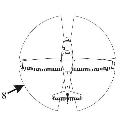
5 000 000 cm / 20 cm = 250 000. 8 At request of pilot vhf direction finding stations normally provide a homing service On a pre selected tower or fss frequency. 27 nm x 1 852 = 50 km
50 km x 1000 = 50 000 m
50 000 m x 100 = 5 000 000 cm
5 000 000 cm / 20 cm = 250 000. 9 Pressure altitude 5 500 feetoutside air temperature oat +15°cindicated airspeed ias 100 kt assuming indicated airspeed ias equal to calibrated airspeed cas true airspeed tas would be closest to On a pre selected tower or fss frequency. 27 nm x 1 852 = 50 km
50 km x 1000 = 50 000 m
50 000 m x 100 = 5 000 000 cm
5 000 000 cm / 20 cm = 250 000. 10 What the magnetic track from oshawa cyoo to lindsay cnf4 On a pre selected tower or fss frequency. 27 nm x 1 852 = 50 km
50 km x 1000 = 50 000 m
50 000 m x 100 = 5 000 000 cm
5 000 000 cm / 20 cm = 250 000. 11 Wind 250°t at 20 kt true air speed 105 kt track 010°tusing above information computed heading and groundspeed en route oshawa to lindsay nearest to On a pre selected tower or fss frequency. 27 nm x 1 852 = 50 km
50 km x 1000 = 50 000 m
50 000 m x 100 = 5 000 000 cm
5 000 000 cm / 20 cm = 250 000. 12 En route from oshawa to lindsay you pass through cya 520 t you must be more alert Civilian flight training activity. 27 nm x 1 852 = 50 km
50 km x 1000 = 50 000 m
50 000 m x 100 = 5 000 000 cm
5 000 000 cm / 20 cm = 250 000. 13 The estimated flight time from lindsay to gananoque at 5 500 feet with a groundspeed of 100 kt nearest to note add an extra 2 minutes each 1 000 feet of climb Civilian flight training activity. 27 nm x 1 852 = 50 km
50 km x 1000 = 50 000 m
50 000 m x 100 = 5 000 000 cm
5 000 000 cm / 20 cm = 250 000. 14 The highest obstacle within 5 nm either side of your track from lindsay to gananoque is Civilian flight training activity. 27 nm x 1 852 = 50 km
50 km x 1000 = 50 000 m
50 000 m x 100 = 5 000 000 cm
5 000 000 cm / 20 cm = 250 000. 15 While on track abeam peterborough you wish to obtain latest weather kingston to get some indication of what conditions will be at gananoque what would be most appropriate station and frequency to call this information Toronto/buttonville radio 26 7 mhz. 27 nm x 1 852 = 50 km
50 km x 1000 = 50 000 m
50 000 m x 100 = 5 000 000 cm
5 000 000 cm / 20 cm = 250 000. 16 Your aircraft crosses town of bridgenorth n44°23'w78°23' at 1810z at 1822z your aircraft over town of norwood n44°23' w77°59' your eta at gananoque airport will be closest to Toronto/buttonville radio 26 7 mhz. 27 nm x 1 852 = 50 km
50 km x 1000 = 50 000 m
50 000 m x 100 = 5 000 000 cm
5 000 000 cm / 20 cm = 250 000. 17 You note your position north of track over town of marlbank n44°26'w77°05' using opening and closing angles method you would alter heading to right Toronto/buttonville radio 26 7 mhz. 27 nm x 1 852 = 50 km
50 km x 1000 = 50 000 m
50 000 m x 100 = 5 000 000 cm
5 000 000 cm / 20 cm = 250 000. 18 What class of airspace would you be flying through when your aircraft at 5 500 asl over marlbank n44°26' w77°05' Toronto/buttonville radio 26 7 mhz. 27 nm x 1 852 = 50 km
50 km x 1000 = 50 000 m
50 000 m x 100 = 5 000 000 cm
5 000 000 cm / 20 cm = 250 000. 19 With vor receiver tuned to coehill vor n44°40' w77°50' when you are over town of marlbank n44°26' w77°05' cdi should be Centred with a 'from' indication when obs 23°. 27 nm x 1 852 = 50 km
50 km x 1000 = 50 000 m
50 000 m x 100 = 5 000 000 cm
5 000 000 cm / 20 cm = 250 000. 20 Due to poor weather you decide to divert to kingston cygk but you become disoriented and lost to help you find airport kingston fss could provide you with a 5 Centred with a 'from' indication when obs 23°. Vdf (vhf direction finder) on 122 5. Exclusive rights: Content under private and protected license, reproduction prohibited and prosecuted.