The east end of a runway oriented east and west is numbered ? Observation > registration
The west end of a runway oriented east and west is numbered ?
The west end of a runway oriented east and west numbered
The north end of a runway oriented north and south is numbered ?
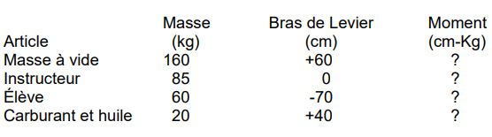
The north end of a runway oriented north and south numbered The south end of a runway oriented north and south numbered If a heading of 250°m maintains your outbound track of 242°m required heading to maintain reciprocal track back to your departure point would be Select correct statements regarding aerodrome information a circuits are right hand on runway 13 and 20 b aircraft radio controlled aerodromelighting available c there are papi lights on both runway 31 and 13 d customs service available e the control zone extends 7 nm f there an fss at aerodrome g aviation gasoline available 2 Calculate fuel requirement using above information average fuel consumption 5 5 gph total flight time 1 hour and 30 minutesadd 4 gallons taxi take off and climb 8 One minute of latitude equal to 9 The large bold number '18' southeast of peterborough airport represents the given quadrangle 3 Highest terrain plus 328 ft or highest known obstruction whichever higher. 10 The hypsometric tinting on chart indicates that between lindsay and norwood airports flight will be conducted over a ground elevation between 3 Highest terrain plus 328 ft or highest known obstruction whichever higher. 11 The highest obstacle within 5 nm either side of your track from lindsay to norwood ft asl 3 Highest terrain plus 328 ft or highest known obstruction whichever higher. 12 The dashed circle around peterborough represents a n 3 Highest terrain plus 328 ft or highest known obstruction whichever higher. 13 Approaching norwood you decide to get latest weather kingston what would be most appropriate station and frequency to call 5 Highest terrain plus 328 ft or highest known obstruction whichever higher. Frame comm
rco london rdo 126 7 (fise)
fise flight information service en route. 14 When a vfr flight plan has been filed and no search and rescue time has been specified in flight plan pilot in command shall file an arrival report with appropriate ats unit not later than hour after last reported eta. Frame comm
rco london rdo 126 7 (fise)
fise flight information service en route. 15 Due to deteriorating weather you decide to divert to kingston n44°13' w76°35' but you become disoriented to assist in locating airport kingston fss could give you a 5 hour after last reported eta. Frame comm
rco london rdo 126 7 (fise)
fise flight information service en route. 16 Choose statement that describes acronym 'vor' A short range navigation aid providing continuous 36 degree data. Frame comm
rco london rdo 126 7 (fise)
fise flight information service en route. 17 Indicate satellite constellations compatible with gnss satellite navigation receivers Gps glonass galileo beidou. Frame comm
rco london rdo 126 7 (fise)
fise flight information service en route. 18 What the magnetic variation at gatineau casino qc heli 6 Gps glonass galileo beidou. Frame comm
rco london rdo 126 7 (fise)
fise flight information service en route. 19 What class of airspace does dashed line around calgary international airport represent 7 Gps glonass galileo beidou. Frame comm
rco london rdo 126 7 (fise)
fise flight information service en route. 20 Refer to canada flight supplement extract the heliport at st jérome hydro québec que you will be conducting operations at st jérome heliport who should you contact permission to operate at heliport 8 Hydro québec at 5 4 346 755. Frame comm
rco london rdo 126 7 (fise)
fise flight information service en route. Exclusive rights: Content under private and protected license, reproduction prohibited and prosecuted.